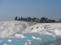
 Pamukkale is one of the highlights of Turkey, and also referrers to Cotton castle in Turki.
 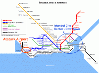 Istanbul city airports, location direction and maps of the all airports in Istanbul. How m.
 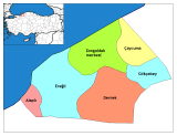 Zonguldak on the western part of Black Sea Region is a rich land for the history and ancie.
 Igdir City Guide
Igdir , is an eastern Anatolian city located on fertile mountan, plains and plateaus of eastern Turkey.
Turkey highest mountain Agri Mt. is rising on south east part of Igdir with it's magnificence.
Located
and established on a land of mountainous terrain has some differences
with other cities of Turkey as for the climate and plant cover. The
land on this area provides availability and fertile opportunities for
agriculture especially the land on Igdir Plain mainly for cotton plant
and fruits.
Fruit growing, agriculture , viticulture /
viniculture and ceral plant agriculture were some of the agriculture
types which had given a big economical power to the area especially
during Urartus.
For over thousands of years, from long time ago
being a settlement for the first time for Hurrians, and many other
civilizations over the history, and became part of Ottoman Empire's
land after the battle of Caldiran. Historical silk road which goes into
central Anatolia was passing through Igdir.
Agri
Mountain is one of the most highlight and values of tourism and tourist
places, it provides opportunities and available racecourses of mountain
sports for especially those who are interested in mountain climbing.
It
carries Ataturk's (Mustafa Kemal Ataturk) a portrait sculpture on the
top of mountain which was ordered to make by Army Major Cevdat Sunay
in 1937.
Besides all these, many of the scientist and geologist
had performed climbing on Agri Mountain in order to make research and
examine the mountain.
Places to Visit in Igdir
Mount
Agri; Being a border between Iran and Igdir and having a height of 5165
meter high , it is an old volcanic mountain on east side of Turkey.
Harmandoven
Caravansary; This caravansary master pieces established by Seljuks
Empire in 12 century is located on Historic Silk Road on the route of
Batum Tebriz Caravan Road.
Tombs with battering-ram; In the plain of Igdir, each of these
tombs have battering-ram on top was left from the era of Kara Koyunlu
(Black Sheep Turkomans) Federation.
Igdir Castle (Castle of Korhan); Located 36 km away from city center, on the foot of Agri Mountain.
Mosques; Asma Village Mosque and Aralik Village mosque.
Tombs; Cakirtas Amarat Kulyusuf Tomb, Tomb of Aralik Haci Ibrahim
Godek, Tomb of Karakoyunlu (Black Sheep Tukomans) Garip Seyit and
Himmet Sayah Tomb.
Igdir Caravansary; This Caravansary was
established during the age of Chief of Surmeli Serafeddin Ejder located
31 km away from the city center.
Karakale Caravansary is 25 kilometers away from Igdir, on the south part of Aras River.
Hamam (Turkish Bath) of Aralik Ortakoy.
Historical Bridges; Alikocek / Elli Kuce Creek Bridge, Acisu Bridge, Tuzluca, Agabey and Incesu Bridges.
Karakale Ruins and Ancient City is within the border of Armenia on the west of Igdir Plain.
Foot and shores of Aras River.
Provinces of Igdir
Karakoyunlu, Igdir Center, Tuzluca and Aralik.


Igdir description (9)

Latest 5 Comments & Request: